Table of Contents
Mapping the size and shape of giant icebergs in Antarctica is a challenging task, but a new study has found a way to do it using Artificial Intelligence. The study, published today in The Cryosphere, was led by Anne Braakmann-Folgmann, who did the research as a PhD student at the University of Leeds in the UK and now works at the Arctic University of Norway in Tromsø.
Why are giant icebergs important?
Giant icebergs are massive chunks of ice that break off from glaciers or ice shelves and drift into the ocean. They can be as large as cities or even countries, and they have a significant impact on the Antarctic environment. They affect the ocean’s physics, chemistry, and biology, as well as the maritime operations in the region. They also release large amounts of freshwater and nutrients into the ocean as they melt, which can influence the climate and marine ecosystems.
Therefore, it is essential to locate and monitor the giant icebergs and to measure how much meltwater they produce. However, this is not an easy task, as the icebergs are often hidden by clouds or darkness, and they can be confused with other features in the satellite images.
How does Artificial Intelligence help?
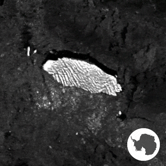
The study used an innovative approach based on Artificial Intelligence to map the giant icebergs using radar images from the Copernicus Sentinel-1 mission. Unlike camera-like instruments, radar can penetrate clouds and work in the dark, making it ideal for observing the Antarctic region. In most radar images, the icebergs appear as bright spots against the darker background of the ocean and the sea ice, making them easier to detect.
However, there are still some challenges, such as distinguishing the icebergs from the rough sea ice or the wind-blown ocean or separating the main iceberg from the smaller fragments that break off from it. Moreover, the Antarctic coastline can sometimes look like an iceberg in the radar images, leading to false detections.
To overcome these challenges, the study used a neural network, which is a type of Artificial Intelligence that can learn from data and make predictions. The neural network was designed to map the extent of the icebergs in the radar images, taking into account the complex and non-linear relationships between the image pixels and the iceberg outlines.
The neural network was trained using manually drawn outlines of the icebergs as the target, and it was able to refine its predictions by comparing them with the target and adjusting its parameters accordingly. The training stopped automatically when the neural network reached its best performance, ensuring its reliability and adaptability.
How well does it work?
The study tested the neural network on seven giant icebergs, with sizes ranging from 54 sq km to 1052 sq km, which are comparable to the areas of Bern in Switzerland and Hong Kong, respectively. The icebergs were observed in different settings, such as seasons and years, using between 15 and 46 radar images for each iceberg. The dataset covered the period from 2014 to 2020.
The results showed that the neural network was very effective in mapping the iceberg extent, even in difficult conditions. It was also able to identify the largest iceberg in each image, which is important for tracking the changes in iceberg area and thickness over time. The neural network outperformed the standard segmentation algorithms, which often selected smaller icebergs or the coastline instead of the actual iceberg.
The study demonstrates the potential of Artificial Intelligence for mapping giant icebergs in Antarctica using radar images and provides a valuable tool for understanding the role of icebergs in the Antarctic environment.